舆图

示意图,边界据 Natural Earth,不作为划界依据。
更多资料
- 所属行政区
- 肯德瓦县
百科(英文)
这个词条没有中文维基百科条目,下面是英文维基百科的原文。
Punasa is a town and a Nagar panchayat in Khandwa district of Madhya Pradesh, India. It is also a Tehsil Headquarter.
Geography
Punasa is located at 22.23°N 76.38°E / 22.23; 76.38 and has an average elevation of 244 m (801 ft).
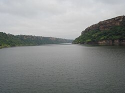
Punasa is an ancient town, with many places of worship, like many other cities in India. The town is over a thousand years old and is surrounded by a forest in the Narmada river valley. It is 120 km (75 mi) from Indore, the commercial capital of the state.
Demographics
It had a total population of 7,225 as per the 2011 Census of India.
Indira Sagar Dam
The Indira Sagar Dam is a multipurpose project of the state Madhya Pradesh on the Narmada River at the town of Narmada Nagar, Punasa in the Khandwa district of Madhya Pradesh in India. The foundation stone of the project was laid by late Smt Indira Gandhi, former Prime Minister of India on 23 October 1984. The construction of the main dam started in 1992. The downstream projects of ISP are Omkareshwar, Maheshwar, and Sardar Sarovar Project. To build it, a town of 22,000 people and 100 villages were displaced.
Transportation
Punasa is 55 km away from District Headquarters Khandwa and 115 km away from Division Headquarter Indore and 205 km away from state capital Bhopal.
Punasa is connected by private bus services to all nearest major cities.
以上摘自英文维基百科「Punasa」(去掉了表格、图片、参考文献和外部链接),按 CC BY-SA 4.0 使用。