舆图

示意图,边界据 Natural Earth,不作为划界依据。
更多资料
- 人口(Wikidata)
- 112,140(2024 年)
- 面积
- 29.7 平方千米
- 海拔(Wikidata)
- 112 米
- 所属行政区
- 甲米地省
- 设立
- 1857 年
- 邮政编码
- 4116
- 电话区号
- 46
- 邻接
- 比尼扬 (菲律宾)、Silang
灰色斜体的是 Wikidata 里没有中文名的,照录英文名。
人口变化
| 年份 | 人口 | 较上一次 | |
|---|---|---|---|
| 1903 | 2,606 | ||
| 1918 | 2,818 | +8.1% | |
| 1939 | 5,394 | +91.4% | |
| 1948 | 5,597 | +3.8% | |
| 1960 | 8,212 | +46.7% | |
| 1970 | 20,123 | +145.0% | |
| 1975 | 51,004 | +153.5% | |
| 1980 | 65,014 | +27.5% | |
| 1990 | 28,247 | -56.6% | |
| 1995 | 35,686 | +26.3% | |
| 2000 | 47,856 | +34.1% | |
| 2007 | 68,135 | +42.4% | |
| 2010 | 74,986 | +10.1% | |
| 2015 | 97,557 | +30.1% | |
| 2020 | 106,256 | +8.9% | |
| 2024 | 112,140 | +5.5% |
Wikidata 记录的历次人口数(普查和估计混在一起,口径可能不同)。
气候
平均最高气温平均最低气温降水量
| 1月 | 2月 | 3月 | 4月 | 5月 | 6月 | 7月 | 8月 | 9月 | 10月 | 11月 | 12月 | 全年 | |
|---|---|---|---|---|---|---|---|---|---|---|---|---|---|
| 平均最高气温(°C) | 29.0 | 30.0 | 32.0 | 34.0 | 32.0 | 31.0 | 29.0 | 29.0 | 29.0 | 29.0 | 30.0 | 29.0 | — |
| 平均最低气温(°C) | 20.0 | 20.0 | 21.0 | 22.0 | 24.0 | 24.0 | 24.0 | 24.0 | 24.0 | 23.0 | 22.0 | 21.0 | — |
| 降水量(毫米) | 10 | 10 | 12 | 27 | 94 | 153 | 206 | 190 | 179 | 120 | 54 | 39 | — |
| 降雨日数(天) | 5.2 | 4.5 | 6.4 | 9.2 | 19.7 | 24.3 | 26.9 | 25.7 | 24.4 | 21 | 12.9 | 9.1 | — |
数据摘自英文维基百科「Carmona, Cavite」条目里的气候表,按 CC BY-SA 4.0 使用。原表标题:Carmona, Cavite。原表注明的数据来源:Meteoblue (Use with caution: this is modeled/calculated data, not measured locally.)。气象站不一定在城区,统计年份见原表标题;以气象部门公布的为准。
百科(英文)
这个词条没有中文维基百科条目,下面是英文维基百科的原文。
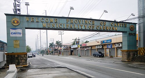
Carmona ([kaɾˈmɔna]), officially the City of Carmona (Tagalog: Lungsod ng Carmona), is a component city in the province of Cavite, Philippines. According to the 2024 census, it has a population of 112,140 people.
Carmona is the youngest city in the Philippines, having attained cityhood on July 8, 2023. It is the 149th city created in the country.
Etymology
By virtue of a decree issued on February 20, 1857, by Queen Isabella II of Spain through Governor General Fernándo Norzagaray y Escudero, Latag became a separate municipality with the name it bears today: Carmona, named after the city of the same name in the province of Seville, Spain.
History
Early history
Carmona was formerly a settlement called Latag, which was annexed to the town of Silang upon the latter's creation in 1595. The origins of its name are unknown. In 1856, the settlement's inhabitants demanded the conversion of Latag into a town, spearheaded by Tiburcio Purificacion.
Carmona history started with three brothers who came to the land of Carmona, which was at the time called Labac.
Spanish colonial era
In 1595, Silang was established as a town. The former sitio of Labac became Barrio Latag, while Carmona remained part of Silang. This was typical of the early Spanish period, when Silang's jurisdiction included areas that are now separate municipalities, such as Indang, San Francisco de Malabon (now General Trias), and Maragondon.
On March 9, 1746, a decree determined the boundaries of Silang and Biñan signed by Mayor Pedro Calderon Enriquez.
On November 15, 1759, two years after securing the independence of Carmona, the principales requested the Governor of Cavite for the reversal of the Canon on communal lands after constructing their own public buildings and irrigation works.
In 1838, the movement of the inhabitants of Latag to become a town started.
On February 20, 1857, due to its distance from the mother town, the principales and the incumbent Cabeza de Barangay of Barrio Latag petitioned for its separation and conversion into a municipality.
Geography
Carmona is located on the easternmost part of the province of Cavite, 48 kilometres (30 mi) south of Manila, 28 kilometres (17 mi) from the provincial capital Imus, and 13 kilometres (8.1 mi) from Biñan. It is bounded on the north, east and south by the City of Biñan, Municipality of General Mariano Alvarez (GMA) on the north-west and Silang on the south-west. The geographic coordinates of Carmona are about 14.32° latitude and 121.06° longitude.
The topography of Carmona is generally flat to strongly rolling or sloping, partly lowland and partly hill. Carmona is divided into four physiographical areas: the lowest lowland area, the lowland area, the central hilly area and the upland mountainous area.
The city is also within the path of a fault line, the Valley Fault System which starts from the Sierra Madre mountains.
Barangays
Carmona is politically subdivided into 14 barangays, as indicated in the matrix below and the image herein. Each barangay consists of puroks and some have sitios. The seat of government is in Barangay 4.
Land area
With a total land area of 29,749,874 square meters (320,224,980 sq ft), Carmona represents 2.17% of the total land area of the province. These areas are currently occupied by 14 barangays of which 7 are considered Poblacion barangays and 7 others are regular barangays.
Demographics
In the 2024 census, the population of Carmona was 112,140 people, with a density of 3,800 inhabitants per square kilometer or 9,800 inhabitants per square mile.
In the 2010 census, Carmona had a total population of 74,986 which represented a total number of households at 14,885.
Population density
The highest densities are found in the Poblacion area (Barangays 1 to 8) and Barangays Milagrosa and Maduya, where land areas are significantly lower than the other barangays. Barangay Lantic posted development of the Kuok Property within the Lantic area; it is expected that the density will increase within the ten-year period.
Population distribution
Carmona's population is concentrated in Barangays 1 to 8 at the Poblacion area. Barangay Lantic is the most populated barangay, which posted a total population of 24,721. Dense population is also found in Barangay 9, the central business district of the municipality. Most population catalysts such as banks, town center, and commercial establishments are found in the Poblacion area.
Language
The main language spoken is Tagalog. In some areas they speak Chabacano or Chavacano, sometimes referred to by linguists as Philippine Creole Spanish, a Spanish-based creole language spoken in the Philippines. English is considered as the second language and is widely used as medium of communication in business and higher education.
Economy
Poverty incidence of Carmona (%)
Source: Philippine Statistics Authority
Cottage industries include metal works, metalcraft, footwear industries, concrete products, tricycle assembly, rattan handicrafts, and bakeries. Manufacturing firms engaged in handicraft (bags and shoes), furniture making, business retailing, personal and business services, and food-based enterprises contribute to the municipality's trade and commerce. Mercantile activities in the municipality are concentrated in the Poblacion area and along Governor's Drive. Carmona has been classified as a first-class municipality since July 1996, brought about by industrialization, real estate development, and commercial activities.
Carmona's progress accelerated after the conversion of more than 50 hectares (120 acres) of farmlands into industrial areas in 1998. Garment industries, steel fabrication, microchips and semi-conductors, tool fabrication, bus assembly, bulb factories, die casting, and other small and medium-scale industries currently operate in the municipality. These investments continue to provide local employment, generate export earnings, increase municipal revenues, and serve as vehicles for technology transfer. Foreign investments are pouring in as export-oriented industries continue to flourish.
Government
Local government
The city of Carmona is governed by a city mayor designated as its local chief executive and by a city council as its legislative body in accordance with the Local Government Code. The mayor, vice mayor, and councilors are elected directly by the people through an election that is being every three years.
Elected officials
List of local government officials since June 30, 2025.
Former municipal mayors
Marcelino P. Clarito
Marcelo Reyes
Martin Reyes
Prudencio Torres
Marcelo Reyes (re-elected)
Juan R. Alumia
Estanislao G. Paular (1931–1937)
Marciano Mapanoo (1938–1941)
Candido G. Hebron (1942–1943)
Juan Zamora (1943–1944)
Alfredo Anulat (1944–1945)
Arsenio Mapalad (1945–1946)
Bernardo B. Hebron (1946–1955)
Eulalio Reyes (1955–1956)
Cesar E. Casal (1956–1979)
Felino L. Maquinay (1980–1986)
Estelito Torres (OIC, 1986–1988)
Felino Maquinay (1988 – February 1990)
Rolando Rosas (February 1990 – 1995)
Roy M. Loyola (1995–2004; 2007–2010; 2019–2022)
Dahlia A. Loyola (2004–2007; 2010–2019; 2022–present)
Healthcare
The Pagamutang Panglungsod ng Carmona (lit. 'Carmona City Hospital' and the Rural Health Unit (RHU) are government-owned and run healthcare facilities in the town.
The main health center in the city is located in Barangay 4. A total of eleven barangay health centers, or substations, of the RHU are established in different barangays.
In addition to the rural health units and the Pagamutang Panglungsod, there are also private clinics and hospitals operating in the city. Eleven clinics are privately owned, and one clinic is under the supervision of government health workers.
Education
The education sector in Carmona has improved in many aspects of endeavor. In line with the local government's thrust of enhancing quality education, the Department of Education (DepEd), particularly the City Schools Division of Carmona, and Carmona National High School, with the full support of the local government unit, implemented various programs and projects that intensified the education sector's efforts to achieve its goals.
As early as 1995, various programs for the improvement of quality education started with a vision of producing competitive students at both the elementary and secondary levels. Carmona posted a literacy rate of 89%. The local government started with the computerization of all schools. Each public school was given computer units, and students were provided with computer lessons. This is in consonance with the belief that modern technology and equipment are considered factors in enhancing better education. To address the increasing number of enrollees and students, the LGU conceptualized the construction of 2-story buildings in different schools in Carmona.
At present, the municipality has a substantial number of classrooms and teachers to meet the learning needs of the school-age population.
以上摘自英文维基百科「Carmona, Cavite」(有删节;去掉了表格、图片、参考文献和外部链接),按 CC BY-SA 4.0 使用。全文和最新版本请看原文。