舆图

资料
- 所在国家 / 地区
- 美国
- 坐标
- 北纬 36.11°,西经 82.11°
- 所属山脉
- Unaka Range
百科(英文)
这个词条没有中文维基百科条目,下面是英文维基百科的原文。
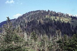
Roan Mountain is a 6,277 ft (1,913 m) mountain straddling the North Carolina/Tennessee state line in the Unaka Range of the Southern Appalachian Mountains in the Southeastern United States. The range's highpoint, Roan is clad in a dense stand of Southern Appalachian spruce–fir forest and includes the world's largest natural rhododendron garden and the longest stretch of grassy bald in the Appalachian range. The Roan Highlands contain the highest quality remaining stretch of Fraser fir forest throughout the tree's entire range. The Cherokee National Forest and Pisgah National Forest converge atop the mountain, with Roan Mountain State Park located near its northern base. The Appalachian Trail traverses most of the Roan's crest. The Roan High Knob Shelter is the highest back-country shelter on the entire 2,174-mile (3,499 km) trail.
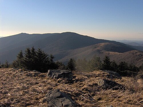
Roan Mountain comprises the greater part of the Roan Highlands, a 20-mile (32 km) massif stretching from Big Rock Creek in the west to U.S. Route 19 in the east. Most of this massif lies along the Tennessee-North Carolina border, between Carter County and Mitchell County. Yellow Mountain and Little Hump Mountain, on the northern tip of the massif, are part of the Roan Highlands but are generally not considered part of Roan Mountain proper. Roan Mountain encompasses five summits, which are divided into two sections by Carver's Gap. The first section—composed of Roan High Bluff and Roan High Knob—lies west of Carver's Gap and is characterized by a thick coniferous forest. This part of Roan is shaped something like the body of a double-humped camel, with the "humps" being High Bluff and High Knob. Tollhouse Gap lies between the two peaks and contains the rhododendron gardens. The second section of Roan Mountain—known as Grassy Ridge—is east of Carver's Gap, and is the longest stretch (approx. 7 mi or 11 km) of grassy bald in the Appalachian Mountains. A grassy bald is a type of highland meadow characterized by thick grass and sparse tree coverage. The three peaks atop Grassy Ridge are Round Bald, Jane Bald, and Grassy Ridge Bald. The bald area spans the summits of all three, covering an area roughly equal to 1,000 acres (400 hectares).
Summits
Roan Mountain contains five peaks:
Roan High Knob, located between Carver's Gap and Tollhouse, is the highest point on Roan Mountain with an elevation of 6,277 feet (1,913 m). The Tennessee-North Carolina border crosses its summit. High Knob is the highest point in Tennessee outside of the Great Smoky Mountains and is the 15th-highest peak in the eastern United States. The Appalachian Trail crosses High Knob's western slope, with a well-marked spur trail leading to the summit. The Roan High Knob Shelter is a few feet from the summit. The distance to the horizon (ignoring the effect of atmospheric refraction and natural obstructions) from Roan High Knob is approximately 164 miles (264 km).
Roan High Bluff, on the mountain's western end at 36°05′35″N 82°08′43″W, has an elevation of 6,260 feet (1,910 m) and is entirely within North Carolina. Unlike its sister peak, High Bluff is steep, rising sharply toward the summit with a rapid 1,000-foot (300 m) drop on its northwest side. While High Bluff's actual summit is closed to the public, an observation platform sits some 20 feet (6.1 m) below it and offers a 180-degree view of the valley to the northwest. The platform can be accessed via the Cloudland Trail, which rises out of Tollhouse Gap.
Round Bald rises near the center of the Roan massif. It has an elevation of about 5,824 feet (1,775 m) and overlooks Carver's Gap at the far western end of Grassy Ridge. The Appalachian Trail (following the state border) crosses its summit, first passing through a sparse tree line on the mountain's northwestern slope before emerging in the bald area near the top. There is a panoramic view from the summit, where it is possible to see the skyline of Charlotte, over 150km distant.
Jane Bald is a small knob between Round Bald and Grassy Ridge Bald, with an elevation of about 5,811 feet (1,771 m).
Geology
The mountains were formed between 200 million and 400 million years ago during the Appalachian orogeny, when the North American and African plates collided, thrusting the rock upward. Among the rocks that make up Roan Mountain, the oldest are a type of metamorphic rock known as Cranberry gneiss. Formed over a billion years ago from ancient ocean sediments, they are among the oldest in the United States. Roan gneiss, another type of metamorphic rock found on the mountain, was formed roughly 800 million years ago. Also in abundance is Beech granite, a type of igneous rock believed to be 700 million years old.
Ecology
The grassy Appalachian balds and Southern Appalachian spruce–fir forest of the Roan are globally imperilled ecosystems. The Roan Highlands are a biodiverse region which hosts dozens of rare, threatened, and endangered species. Five federally endangered species and one federally threatened species can be found at the Roan.
History
Native Americans were the first human visitors to Roan Mountain. A Catawba legend tells of a great battle with the Cherokee atop the mountain that left the rhododendron colored crimson and parts of the mountain treeless. While there is no hard evidence that such a battle ever occurred, numerous Native American settlements have been found around the base of the mountain, and the Cherokee settlement of Old Fields stood near modern-day Elizabethton, Tennessee.
Throughout the 18th and 19th centuries, botanists paid frequent visits to the area to collect plant specimens. Among them were John Bartram, who crossed the Roan Highlands in the late 1730s while studying the botanical make-up of what is now the southeastern United States. Andre Micheaux followed in 1794, discovering several alpine species rarely found outside of the New England and Canadian latitudes. In 1799, John Fraser explored Roan Mountain, collecting specimens of rhododendron and noting the existence of the fir tree that now bears his name. Other early explorers included Elisha Mitchell, for whom Mount Mitchell is named, Thomas L. Clingman, who had also measured Kuwohi, and Harvard botanist Asa Gray. The origin of the name Roan is unknown. Hypotheses include that roan refers to the reddish splotches of rhododendron blooms in the spring or mountain ash berries in the fall, or that it refers to Daniel Boone's roan horse.
American Revolutionary War
In 1780, at the height of the American Revolution, British General Charles Cornwallis opened his invasion of the southern colonies with the capture of Charleston, South Carolina, and a victory over American forces at Camden. With South Carolina apparently secure, Cornwallis marched north toward Charlotte, North Carolina. During this march, Cornwallis dispatched a band of Loyalists under the command of Major Patrick Ferguson to raid western Carolina.
Cloudland Hotel
Tourists had been visiting Roan Mountain since the mid-19th century.
Access
State Routes TN 143/NC 261—which connect the village of Roan Mountain with Bakersville, North Carolina—ascend the northeast slope of Roan Mountain, crossing its crest at Carver's Gap. The Appalachian Trail can be accessed from Carver's Gap (it runs perpendicular to the highway), where there is a small parking lot. To the east (across the street from the parking lot), the trail ascends Round Bald and proceeds across Grassy Ridge. To the west, the trail swings around Roan High Knob just over one mile (1.6 km) to Tollhouse Gap, where it turns north.
A paved road crosses the south side of Roan High Knob, connecting Carver's Gap with Tollhouse Gap, although this road is closed in winter. This road leads to the Cloudland Trailhead, which crosses the Rhododendron Gardens and ascends the western slope of Roan High Bluff to the observation platform just below the summit. The trail is just over a mile (1.6 km) long.
The Roan High Knob Shelter, near the summit of Roan High Knob, can accommodate 15 backpackers. The shelter is maintained by the Tennessee Eastman Hiking and Canoeing Club. However, Overmountain Shelter (found approximately 5.5 miles (8.9 km) from Carver's Gap towards 19-E) has been indefinitely closed since September 4, 2019. The U.S. Forest Service has deemed this famous red barn structurally unsound.
The Appalachian Trail, after traversing Iron Mountain to the west, crosses Hughes Gap and ascends Roan's northern slope to Tollhouse Gap. From there, it makes a sharp turn to the east, crossing Roan High Knob, Carver's Gap, Grassy Ridge, and Yellow and Little Hump Mountains before descending to US-19 and the White Rocks Mountain area. From the slopes of Old Black in the Great Smoky Mountains, some 150 miles (240 km) to the south, to Mount Washington in the White Mountains of New Hampshire, some 1,500 miles (2,400 km) to the north, Roan Mountain is the only area where the trail rises above the 6,000-foot (1,800 m) mark.
以上摘自英文维基百科「Roan Mountain (Roan Highlands)」(有删节;去掉了表格、图片、参考文献和外部链接),按 CC BY-SA 4.0 使用。全文和最新版本请看原文。