舆图

资料
百科(英文)
这个词条没有中文维基百科条目,下面是英文维基百科的原文。
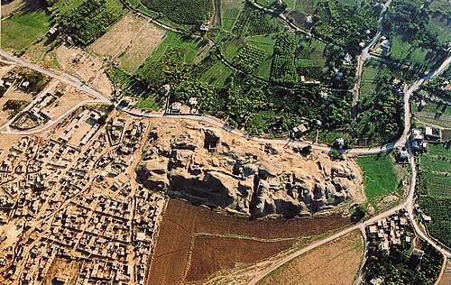
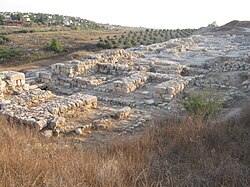
Tell es-Sultan (Arabic: تل السلطان, lit. Sultan's Hill), also known as Tel Jericho or Ancient Jericho, is an archaeological site and a UNESCO World Heritage Site (since 2023) in Palestine, in the city of Jericho, consisting of the remains of the oldest fortified city in the world. The site is managed as a National Archaeological Park by the Palestinian Ministry of Tourism and Antiquities/Department of Antiquities and Cultural Heritage (MoTA–DACH), which oversees on-site conservation in continued partnership with the Sapienza University of Rome archaeological expedition.
It is located adjacent to the Ein es-Sultan refugee camp, 2 km (1.2 mi) north of the centre of the Palestinian city of Jericho. The tell was inhabited from the 10th millennium BCE, which makes Jericho among the oldest continually inhabited cities in the world. The site is notable for its role in the history of Levantine archaeology.
The area was first identified as the site of ancient Jericho in modern times by Charles Warren in 1868, on the basis of its proximity to the large spring of Ein es-Sultan, that had been proposed as the spring of Elisha by Edward Robinson three decades earlier.
History and archaeology
Epipalaeolithic
The droughts and cold of the Younger Dryas came to an end around 9600 BCE, ushering in the Holocene epoch and the Epipaleolithic period of human history. The resulting warmer climate made it possible for Natufian groups to extend the duration of their stay, eventually leading to year-round habitation and permanent settlement. The first permanent settlement at Tell es-Sultan—marked by the construction of Natufian structures—developed between 10,000 and 9000 BCE, which appears to predate the invention of agriculture. Tell es-Sultan was a popular camping ground for Natufian hunter-gatherer groups due to the nearby Ein as-Sultan spring; these hunter-gatherers left a scattering of crescent-shaped microlith tools behind.
Pre-Pottery Neolithic A (PPNA)
The Pre-Pottery Neolithic A phase at Tell es-Sultan (c. 8500–7500 BCE) saw the emergence of one of the world's first major proto-cities. As the world warmed up, a new culture based on agriculture and sedentary dwelling emerged, which archaeologists have termed "Pre-Pottery Neolithic A" (abbreviated as PPNA), sometimes called the Sultanian era after the town. PPNA villages are characterized by small circular dwellings, burial of the dead under the floor of buildings, reliance on hunting wild game, the cultivation of wild or domestic cereals, and no use of pottery yet.
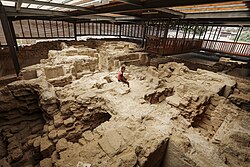
The PPNA-era town, a settlement of around 4 hectares (9.9 acres), contained round mud-brick houses, yet no street planning. Circular dwellings were built of clay and straw bricks left to dry in the sun, which were plastered together with a mud mortar. Each house measured about 5 metres (16 ft) across, and was roofed with mud-smeared brush. Hearths were located within and outside the homes.
The identity and number of the inhabitants of Jericho during the PPNA period is still under debate, with estimates going as high as 2,000–3,000, and as low as 200–300. It is known that this population had cultivated emmer wheat, barley and pulses and hunted wild animals.
The town was surrounded by a massive stone wall over 3.6 metres (12 ft) high and 1.8 metres (6 ft) wide at the base, inside of which stood a stone tower, placed in the centre of the west side of the tell. This tower was the tallest structure in the world until the Pyramid of Djoser, and the second-oldest tower after the one at Tell Qaramel. The wall and tower were built around 8000 BCE. Radiocarbon dating indicates that the tower was built around 8300 BCE and stayed in use until c. 7800 BCE. The wall and tower would have taken a hundred men more than a hundred days to construct, thus suggesting some kind of social organization and division of labour.
Archaeological excavation
The first excavations of the tells around Ain es-Sultan (Arabic: عين سلطان, lit. 'Sultan's spring') were made by Charles Warren in 1868 on behalf of the Palestine Exploration Fund. Warren excavated nine mounds in the area of the spring; during one of the excavations his workmen dug through the mud bricks of the wall without realizing what it was.
The spring had been identified in 1838 in Edward Robinson's Biblical Researches in Palestine as "the scene of Elisha's miracle", on the basis of it being the primary spring near to Jericho. On this basis Warren proposed the surrounding mounds as the site of Ancient Jericho, but he did not have the funds to carry out a full excavation. Believing that it was the spring where Elisha healed, he suggested shifting the entire mound for evidence, which he thought could be done for £400 (equivalent to £40,000 in 2025).
Ernst Sellin and Carl Watzinger excavated Tell es-Sultan and Tulul Abu el-'Alayiq between 1907 and 1909 and in 1911, finding the remains of two walls which they initially suggested supported the biblical account of the Battle of Jericho. They later revised this conclusion and dated their finds to the Middle Bronze Age (1950–1550 BCE).
The site was again excavated by John Garstang between 1930 and 1936, who again raised the suggestion that remains of the upper wall was that described in the Bible, and dated to around 1400 BCE.
Extensive investigations using more modern techniques were made by Kathleen Kenyon between 1952 and 1958. Her excavations discovered a tower and wall in trench I. Kenyon provided evidence that both constructions dated much earlier than previous estimates of the site's age, to the Neolithic, and were part of an early proto-city. Her excavations found a series of seventeen early Bronze Age walls, some of which she thought may have been destroyed by earthquakes. The last of the walls was put together in a hurry, indicating that the settlement had been destroyed by nomadic invaders. Another wall was built by a more sophisticated culture in the Middle Bronze Age with a steep plastered escarpment leading up to mud bricks on top.
Lorenzo Nigro and Nicolo Marchetti conducted excavations in 1997–2000. Since 2009 the Italian-Palestinian archaeological project of excavation and restoration was resumed by Rome "La Sapienza" University and Palestinian MOTA-DACH under the direction of Lorenzo Nigro and Hamdan Taha.
Renewed excavations were carried out at Tell es-Sultan from 2009 to 2023 by the Italian-Palestinian Expedition directed by Lorenzo Nigro for Sapienza University of Rome and Jehad Yasine for the Ministry of Tourism & Antiquities of Palestine.
Walls
The PPNA-era city wall was designed for either defensive or flood protection purposes; the mass of the wall (approximately 1.5 to 2 metres (4.9 to 6.6 ft) thick and 3.7 to 5.2 metres (12 to 17 ft) high) as well as that of the tower suggests a defensive purpose as well. It is suggested to date to approximately 8000 BCE. If interpreted as an "urban fortification", the Wall of Jericho is the oldest city wall discovered by archaeologists anywhere in the world. Surrounding the wall was a ditch 8.2 metres (27 ft) wide by 2.7 metres (9 ft) deep, cut through solid bedrock with a circumference around the town of as much as 600 metres (2,000 ft). Kenyon commented that the "labour involved in excavating this ditch out of solid rock must have been tremendous."
Tower of Jericho
The Tower of Jericho is an 8.5-metre-tall (28 ft) stone structure, built in the Pre-Pottery Neolithic A period around 8000 BCE. It is among the earliest stone monuments of mankind. Conical in shape, the tower is almost 9 metres (30 ft) in diameter at the base, decreasing to 7 metres (23 ft) at the top, with walls approximately 1.5 metres (5 ft) thick. It contains an internal staircase with 22 stone steps.
Current-day management
In 2023, Tell es-Sultan (ancient Jericho) was inscribed on the UNESCO World Heritage List under the name "Tell es-Sultan/Ancient Jericho: A Testimony to Human Civilizations for 11,000 Years," recognized for its continuous sequence of settlement layers spanning the Neolithic period. The site is managed as a National Archaeological Park by the Palestinian Ministry of Tourism and Antiquities/Department of Antiquities and Cultural Heritage (MoTA–DACH), which oversees on-site conservation in continued partnership with the Sapienza University of Rome archaeological expedition. UNESCO has identified the absence of a systematic, holistic conservation strategy as a key management challenge, and a multi-year project launched in 2022 aims to stabilize exposed archaeological remains, mitigate erosion, and strengthen local heritage-management capacity. The site's inscription itself was contested by members of the Israeli government, who argued the location should fall under Israeli rather than Palestinian jurisdiction, though the World Heritage Committee's decision affirmed that Tell es-Sultan lies fully within Palestinian Authority-administered Area A. Ongoing site management involves conservation partnerships aimed at protecting the exposed tell from erosion while maintaining public access.
以上摘自英文维基百科「Tell es-Sultan」(有删节;去掉了表格、图片、参考文献和外部链接),按 CC BY-SA 4.0 使用。全文和最新版本请看原文。