舆图

资料
- 所在国家 / 地区
- 加拿大
- 坐标
- 北纬 51.96°,西经 117.10°
百科(英文)
这个词条没有中文维基百科条目,下面是英文维基百科的原文。
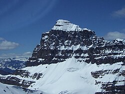
Ernest Peak - a.k.a. Lyell 3, L3 or Mt. Lyell (on maps, etc.) - is the central and highest peak of five distinct subpeaks on Mount Lyell (Canada) and is located on the border of Alberta and British Columbia. (There has been some dispute whether Lyell 2 or Lyell 3 is highest, but according to the recently released and corrected Climbers Guide to The Canadian Rocky Mountains - Rockies West book, the tallest is Ernest Peak). It was named in 1972 by Sydney R. Vallance after Ernest Feuz Jr.
Geology and climate
Due to this peak being the central and tallest subpeak - and thus is "Mount Lyell" - see the Mount Lyell article for geology and climate.
以上摘自英文维基百科「Ernest Peak」(去掉了表格、图片、参考文献和外部链接),按 CC BY-SA 4.0 使用。