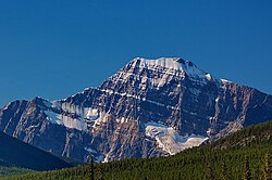
舆图

资料
- 所在国家 / 地区
- 加拿大
- 坐标
- 北纬 52.55°,西经 117.91°
- 所属山脉
- 帕克山脉
百科(英文)
这个词条没有中文维基百科条目,下面是英文维基百科的原文。
Mount Fryatt is Alberta's 26th highest peak. In 1920, it was named after Captain Charles Fryatt, a British merchant seaman who was executed by the Germans during World War I. It lies within peaks that are between the Athabasca and Whirlpool Rivers in Jasper National Park.
The first ascent was made in 1926 by J. W. A. Hickson, Howard Palmer and the guide Hans Fuhrer. The route they took, the South-West Face route, is now the normal line of ascent and descent.
Geology
Mount Fryatt is composed of sedimentary rock laid down from the Precambrian to Jurassic periods. Formed in shallow seas, this sedimentary rock was pushed east and over the top of younger rock during the Laramide orogeny.
Climate
Based on the Köppen climate classification, Mount Fryatt is located in a subarctic climate with cold, snowy winters, and mild summers. Temperatures can drop below -20 °C with wind chill factors below -30 °C. Precipitation runoff from Mount Fryatt drains into tributaries of the Athabasca River.
以上摘自英文维基百科「Mount Fryatt」(去掉了表格、图片、参考文献和外部链接),按 CC BY-SA 4.0 使用。