舆图
巴湾湾 城镇
Bayawan · 中米沙鄢
- 国家 / 地区
- 菲律宾
- 一级行政区
- 中米沙鄢
- 坐标
- 北纬 9.36°,东经 122.80°

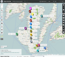
示意图,边界据 Natural Earth,不作为划界依据。
更多资料
- 人口(Wikidata)
- 126,744(2024 年)
- 面积
- 699.1 平方千米
- 海拔(Wikidata)
- 225 米
- 所属行政区
- 东内格罗省
- 设立
- 1872 年
- 邮政编码
- 6221
- 电话区号
- 35
- 邻接
- Ilog、Basay、Mabinay、Santa Catalina
人口变化
| 年份 | 人口 | 较上一次 | |
|---|---|---|---|
| 1903 | 6,099 | ||
| 1918 | 10,283 | +68.6% | |
| 1939 | 15,954 | +55.1% | |
| 1948 | 10,608 | -33.5% | |
| 1960 | 30,429 | +186.8% | |
| 1970 | 44,615 | +46.6% | |
| 1975 | 62,114 | +39.2% | |
| 1980 | 71,153 | +14.6% | |
| 1990 | 78,280 | +10.0% | |
| 1995 | 90,953 | +16.2% | |
| 2000 | 101,391 | +11.5% | |
| 2007 | 110,250 | +8.7% | |
| 2010 | 114,074 | +3.5% | |
| 2015 | 117,900 | +3.4% | |
| 2020 | 122,747 | +4.1% | |
| 2024 | 126,744 | +3.3% |
Wikidata 记录的历次人口数(普查和估计混在一起,口径可能不同)。
百科(英文)
这个词条没有中文维基百科条目,下面是英文维基百科的原文。
Bayawan, officially the City of Bayawan (Cebuano: Dakbayan sa Bayawan), is a component city in the province of Negros Oriental, Philippines. According to the 2024 census, it has a population of 126,744 people.
Bayawan used to be known as New Tolong, and only had its modern name starting 1952. Bayawan became a chartered city in December 2000.
The town is home to the Minagahat language, the Indigenous language of Southern Negros as listed by Komisyon sa Wikang Filipino. The language is vital to the culture and arts of the people of southern Negros.
Etymology
An altercation happened between a priest and the natives that used to live in the area. The town center was previously located in an uphill settlement called 'Omod', and a chapel was erected to serve the religious needs of the new converts. During a mass, a native threw a lance in the priest, who was raising the Holy Host at that time, instantly killing him.
The name "Bayawan" stems from the Visayan term "Bayaw"– to hoist or elevate, in reference to the priest's action just before his death.
History
It was in 1751 when the Spanish friars first established their settlement. 116 years later, Tolong Nuevo (Bayawan's former name) had existed as early as 1868 as part of Tolong Viejo (now the Municipality of Santa Catalina). It was not until 1872 when she was formally organized as a pueblo.
In 1953, the name Tolong Nuevo was changed to Bayawan, by virtue of Republic Act 694 as approved by the 3rd congress of the Philippines, consigning the name “Tolong” into obscurity and deep oblivion soon slowly to be forgotten by the succeeding generations. This made Bayawan a separate municipality.
Cityhood
Bayawan, after meeting all of its requirements for its cityhood, became a city on December 23, 2000, via plebiscite that was set by COMELEC. It boasts its distinction as a "Character City" (International Association of Character Cities) and a pioneer "Healthy City" (DOH certified) in the Philippines. The Asian Institute of Management recognized the city as "one of the Top 10 Best Cities to Live In in the Philippines (Small Cities Category)" under its Competitive Cities Survey of 2007.
Geography
Bayawan is located 102 kilometres (63 mi) from the provincial capital Dumaguete, 183 kilometres (114 mi) from Bacolod, and 95 kilometres (59 mi) from Kabankalan. It is a coastal city with a land area of 69,908 hectares (172,750 acres), the largest in the province and whole Negros island. This accounts for 13% of the province's land area. Mabinay bounds it to the north, Santa Catalina to the south, Tanjay to the east, Basay to the west, and it also shares a boundary with Kabankalan of Negros Occidental on the northwest. The coastline is 15 kilometres (9.3 mi) west to east, with 7 coastal barangays.
Bayawan City is subdivided into three development zones:
The urban area constitutes only 2.3% (15.73 km2) of the city's total area and contains the main institutional, commercial and central business district of the city. It functions as the main economic hub, while economic growth nodes are established in strategically located barangays in the hinterlands.
The sub-urban area is about 14.7% (102.6 km2) of the total area and is set to contain the agro-industrial zones, industrial zones and human settlements. The existing industrial activity (lime plant), the establishment of saw mills, and the identified industrial zones in the area show the natural pattern of development. Residential zones are considered in the sub-urban area to provide settlements for the people in the commercial center and in the industrial zones.
Demographics
In the 2024 census, the city has a population of 126,744 people.
In 2000, 21,814 of 101,391 inhabitants of the city comprise the urban population. The population density is 180/km2, which is manageable compared to other cities in the country.
Economy
Poverty incidence of Bayawan (%)
Source: Philippine Statistics Authority
Bayawan is still largely rural with only 2.25% of its total land area as urban area. The city is basically agricultural and its economy sits on an agricultural platform. Revenues from land farming, livestock production, aqua-culture activities and marine fishing are a major income contribution of the city. In 2000, the assessment of City Agriculture Office (CAO) indicated that agricultural production was valued at Php 2.3 Billion; 91.4% of which came from crop production, 7.9% from livestock production, and 0.7% from fisheries.
On a general scale, the city is not yet self-sufficient since its local revenue is only 12% of the total revenue and 88% comes from its Internal Revenue Allotment (IRA) (Year 2000 Data).
The city has several investment opportunities especially in the field of agro-industry and processing as well as in the processing of marine products. The vast agricultural resources and the LGU's thrust on agricultural development opens avenues of investing in feed mills, palm oil mills, rice mills, corn mills, storage and other farming and post harvest facilities and equipment. Besides agri-industries, the trading and auction markets are already well established in the hinterland barangays especially in Dawis and Kalumboyan.
Environment
Bayawan has one of the most barren mountains in the province. The Department of Environment & Natural Resources (DENR) have classified that 72.7% and 27.3% (198.05 km2) of the total land area of Bayawan as A&D (alienable and disposable) and as forestlands respectively. However, recent assessment of land use utilization shows that only 17.8% of the total land area is used as forestlands. From these, it can be deduced that a large portion of the land area supposedly classified as forestlands are cultivated and unsuitably used. This situation can be attributed to the improper settling and farming practices of the people in the hinterlands. There are uncontrolled and unmonitored conversions of classified forestlands through slash and burn practices, then cultivation by the people in all parts of the upland barangays. However, these lands have or in the process of application for land titles (ownership).
The haphazard conversion and cultivation of the forestlands and denudation of the forest cover have resulted to the perennial problem of flooding in both upland and lowland barangays during rainy season. Its adverse effects include the severe siltation of the three rivers in the city and loss of soil fertility in the hinterlands due to soil erosion and landslides. In addition, some springs has become intermittent (no water flowing during dry season) because of the destruction of their watersheds.
Tourism
Niludhan Falls
Banay Banay Falls
Lourdes Falls
Bayawan Boulevard
Bayawan City Plaza
Bayawan Nature Reserve
Narra Water Park
Bayawan City Waste Management and Ecological Center
Infrastructure
The main infrastructure of the city is concentrated in the city proper, although various dams for agricultural purposes have been constructed to improve irrigation in the farmlands. The connecting road to Kabankalan City has been completed. The 2.5 kilometers long boulevard fronting the beachfront in the city proper is among the longest in the province, and has become a major local venue and tourist attraction.
Transport
As of 2000 the city had 645.23 km of roads; 6.26% of which are National Roads; 19.41% are Provincial Roads; 1.79% are City Roads/Streets; and majority of which is 72.54% are Barangay Roads. Moreover, of the total road length only 5.75% are concrete roads and 2.81% asphalt roads. Of the unpaved roads, only 105 kilometers are gravel roads and the remaining 75.16% or 485 kilometers are earth fill roads. This translates that most of the roads especially the barangay roads in the upland barangays are not passable during bad weather conditions. The road situation affected for the residents in the hinterlands and the farmers have to shoulder very high cost of transporting their products.
The improvement of road infrastructure of the city especially the provincial road that connects the City Proper, Kalumboyan and Manduao to Kabankalan City in Negros Occidental is deemed to open up a new dimension in the economic and social activity of the city.
Flood control and drainage
The city proper of Bayawan experiences flooding during rainy season.
Education
Bayawan City has three tertiary institutions, the Negros Oriental State University (formerly NONAS), City College of Bayawan and Southern Tech College. Nursery education is provided by day-care centers located in each urban barangay.
The public schools in Bayawan are administered by the Schools Division of Bayawan City.
High schools
Integrated schools:
Ali-is Integrated School (formerly Ali-is ES) — Ali-is
Private schools
Bayawan Angelicum Inc. — S. Martinez Street, Ubos
Early Readers Montessorian School, Inc. — F. Teologia Street, Suba
St. Augustine Academy of Bayawan, Inc. — Nat'l Highway, Ubos
Southern Tech College Foundation, Inc. — Nat'l Highway, Villareal
UCCP-Bayawan City Learning Center, Inc. — Zamora Street, Ubos
以上摘自英文维基百科「Bayawan」(有删节;去掉了表格、图片、参考文献和外部链接),按 CC BY-SA 4.0 使用。全文和最新版本请看原文。