舆图

资料
- 所在国家 / 地区
- 美国
- 坐标
- 北纬 18.17°,西经 66.49°
- 所属山脉
- Cordillera Central
百科(英文)
这个词条没有中文维基百科条目,下面是英文维基百科的原文。
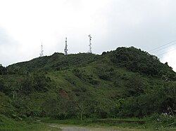
Cerro El Bolo is the highest peak in the municipality of Villalba, Puerto Rico, raising to 1,075 meters (3,527 ft) above sea level. It is part of the Toro Negro State Forest, and is the 10th tallest mountain in Puerto Rico.
Mountain access and hiking trail
The mountain can be reached by following state road PR-143 to km 32.4, where the main entrance of the Toro Negro State Forest is located. Route 143 is part of Puerto Rico's Ruta Panorámica. Route 143 can be accessed via the better-traveled Route 10. From the State Forest's visitors area, Trail #1, known as "Camino El Bolo", makes its way up to Cerro El Bolo.
以上摘自英文维基百科「Cerro El Bolo」(去掉了表格、图片、参考文献和外部链接),按 CC BY-SA 4.0 使用。