舆图

资料
百科(英文)
这个词条没有中文维基百科条目,下面是英文维基百科的原文。
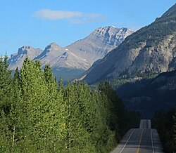
Sunwapta Peak is a peak in the Sunwapta River valley of Jasper National Park, just north of the Columbia Icefield in Alberta, Canada. The peak was named in 1892 after the Stoney language word sunwapta meaning "turbulent river". The mountain can be seen from the Icefields Parkway (Highway 93).
Routes
The normal climbing route (an easy scramble) is via the southwest slopes, requiring an elevation gain of 1,735 m (5,692 ft) to the summit from the trail head beside the Icefields Parkway.
Geology
Sunwapta Peak is composed of sedimentary rock laid down from the Precambrian to Jurassic periods that was pushed east and over the top of younger rock during the Laramide orogeny.
Climate
Based on the Köppen climate classification, Sunwapta Peak is in a subarctic climate zone with cold, snowy winters, and mild summers. Temperatures can drop below −20 °C with wind chill factors below −30 °C. Precipitation runoff from Sunwapta Peak drains into the Sunwapta River which is a tributary of the Athabasca River.
以上摘自英文维基百科「Sunwapta Peak」(去掉了表格、图片、参考文献和外部链接),按 CC BY-SA 4.0 使用。