舆图
米格尔-伊达尔戈 城镇
Miguel Hidalgo · 墨西哥城
- 国家 / 地区
- 墨西哥
- 一级行政区
- 墨西哥城
- 坐标
- 北纬 19.43°,西经 99.20°

示意图,边界据 Natural Earth,不作为划界依据。
更多资料
- 人口(Wikidata)
- 414,470(2020 年)
- 面积
- 69.8 平方千米
- 海拔(Wikidata)
- 2,273 米
- 所属行政区
- 墨西哥城
- 政府首脑
- Mauricio Tabe Echartea
百科(英文)
这个词条没有中文维基百科条目,下面是英文维基百科的原文。
Miguel Hidalgo is a borough (alcaldía) in western Mexico City, it encompasses the historic areas of Tacuba, Chapultepec and Tacubaya along with a number of notable neighborhoods such as Polanco and Lomas de Chapultepec. With landmarks such as Chapultepec Park and the Museo Nacional de Antropología, it is the second most visited borough in Mexico City after Cuauhtémoc where the historic center of Mexico City is located. Tacubaya and Tacuba both have long histories as independent settlements and were designated as "Barrios Mágicos" by the city for tourism purposes.
Geography
The borough is located in the northwest of Mexico City, just west of the historic center. The borough is divided into eighty one neighborhoods called colonias. The largest of these is Bosques de las Lomas at 3.2 km2, and the smallest is Popo Ampliación with only 0.33 km2. It is bordered by the boroughs of Azcapotzalco, Cuauhtémoc, Benito Juárez, Álvaro Obregón and Cuajimalpa, and the State of Mexico to the west. It has a territory of 47.68 km2 which is 3.17 percent of the total Mexico City.
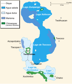
The borough consists of an area which used to the west bank of Lake Texcoco, with three major zones, Tacuba, Chapultepec and Tacubaya. The geography of the borough includes canyons, hills and mesas associated with the Sierra de las Cruces, most present in the southwest bordering Cuajimalpa. In the northeast, mostly defined by the Interior Circuit ringway. The most important elevation is the Cerro de Chapultepec at 2,260masl. The area today is almost completely developed with green spaces mostly limited to parks. The largest green space is Chapultepec Park at 2.2 km2. Parque Lineal was the former rail line of the Ferrocarril de Cuernavaca. The strip was converted into a park in 2011. Where the park crosses Lago Constanza Street in Colonia Anáhuac, there are often cultural events held.
Demographics and socioeconomics
As of 2005, the borough had 106,005 residences of which 25,308 were freestanding houses, 54,079 were apartments and the rests of other types. This total number grew to a total of 123,910. About eighty percent of homes are owned by their residents and not rented. Around 95% have basic services such as electricity and running water. While the borough contains mostly working class areas in and around Tacuba and Tacubaya, the southwest contains some of the most exclusive colonias of the borough.
While most of the borough is residential, the population of the borough has dropped from 650,497 in 1960 to 372,889 in 2010. It is now the twelfth most densely occupied borough of sixteen. Just over eighty eight percent identify themselves as Catholic.
The borough has 112 preschools, 160 primary schools, 79 middle schools, seven vocational/technical high schools and 49 high schools. The borough has an educational program called "Faros del Saber" (Lighthouses of Knowledge), which began in 2001. There are nine installations related to the program: each dedicated to a different field, such as ecology and science and technology, and each designed to promote these fields to the youth of the borough through workshops and various events. The main library of the program is part of CONACULTA and is designed to promote reading.
History
The borough is named after Miguel Hidalgo y Costilla, who began the Mexican War of Independence . The borough was created by fusing various former municipalities such as Tacuba, Tacubaya and the Chapultepec Park area along with the neighborhoods such as Polanco, Lomas de Chapultepec, Bosques de las Lomas, Popotla, Las Pensil, La Argentina, America, Santa Julia and Observatorio. The center of the borough is considered to be Chapultepec Park.
Until the 20th century, Tacuba, Chapultepec and Tacubaya had separate histories, all part of the Federal District of Mexico City during most of this entity's existence under various arrangements. In 1899, the Federal District was divided into the municipality of Mexico and six prefectures, one of which was Tacubaya. This arrangement was reconfirmed in 1917. In 1928, the Federal District was reorganized as a department under the direct control of the federal government. The territory was reorganized into Mexico City proper and thirteen boroughs: Guadalupe-Hidalgo, Azcapotzalco, Iztacalco, General Anaya, Coyoacán, San Ángel, La Magdalena Contreras, Cuajimalpa, Tlalpan, Iztapalapa, Xochimilco, Milpa Alta and Tláhuac. The city proper was divided into twelve districts. What is now Miguel Hidalgo, was part of Mexico City proper.
Chapultepec
The center of the borough is Chapultepec Park. Chapultepec Park, more commonly called the "Bosque de Chapultepec" (Chapultepec Forest) in Mexico, is the largest city park in Latin America, measuring in total just over 686 hectares.
The area has been considered special since long in the pre Hispanic period when it was a ceremonial site and later a retreat for Aztec emperors. There is also evidence of settlements here by the Chichimecas and Toltecs. The Mexicas lived here at before they were expelled by Azcapotzalco. After finally establishing Tenochtitlan, the Mexicas or Aztecs considered Chapultepec sacred. The first aqueduct from there to Tenochtitlan/Mexico City was built by Moctezuma Ilhuicamina. Later Moctezuma Xocoyotzin had fish tanks and gardens constructed on the site. And Nezahualcoyotl had a palace constructed at the base of the hill. After the Conquest, Hernán Cortés tried to take this land for himself but Charles V denied this and made the area the heritage of Mexico City because it contained many of the springs that provided the city with potable water. The second and third sections of Chapultepec were opened in 1962 and 1974 respectively, with the third section from part of the lands which were an old paper factory.
The two most important museums are the Museo Nacional de Antropología and the Chapultepec Castle National History Museum.
Neighborhoods
Neighborhoods (colonias) in the borough include Bosques de las Lomas, Lomas de Chapultepec, Granada, Ampl. Granada, Pensil, Polanco, San Miguel Chapultepec, and the two formerly independent municipalities of Tacuba and Tacubaya.
Tacuba
Tacuba was called Tlacopan in the pre Hispanic period. Tacuba is derived from the former Nahuatl name "Tlacopan" and means place of the jarilla plant. It was conquered by Azcapotzalco which placed Totoquihuatzin as governor. When the Tenochtitlan and Texcoco decided to ally against Azcapotzalco, Tlacopan did not resist and for this reason is considered to be the third of the Aztec Triple Alliance. Tacuba's importance led to the construction of a causeway over the lake linking it with Tenochtitlan. Today, this causeway still exists as a major thoroughfare called Calzada Mexico-Tacuba.
During the Spanish conquest of the Aztec Empire, the Aztecs succeeded at one point in expelling the Spanish from Tenochtitlan in an event called La Noche Triste (The Sad Night). Cortés and his men fled towards Tacuba on the road that still connects it with the historic center of Mexico City. One year later, Cortés returned to Tenochtitlan to conquer it for good. At the intersection of the Mexico-Tacuba Road and Mar Blanco is a still surviving Montezuma cypress tree. According to legend, this is the tree under which Cortés wept.
Economy
Interjet has its headquarters in Lomas de Chapultepec. Google Mexico also has its headquarters in Lomas.
Wamos Air has its Mexico City office in Polanco.
Organizations and diplomatic missions
Most of the diplomatic missions in Mexico City are located in Miguel Hidalgo, mainly in the Lomas de Chapultepec and Polanco area.
Other diplomatic offices
European Commission Delegation
Special Palestinian Delegation
Taipei Economic and Cultural Office in Mexico, the de facto mission of the Republic of China on Taiwan.
United Nations agencies
The International Civil Aviation Organization (ICAO) has its North American, Central American and Caribbean (NACC) Office in Miguel Hidalgo.
Education
Public high schools of the Instituto de Educación Media Superior del Distrito Federal (IEMS) include:
Escuela Preparatoria Miguel Hidalgo "Carmen Serdán" (Argentina Antigua)
International schools in Miguel Hidalgo include:
Lycée Franco-Mexicain (Liceo Franco Mexicano) in Polanco
The Plantel Lomas Kindergarten Prado Norte facility of the Campus Poniente/Campus West (formerly Campus La Herradura) of the Colegio Alemán Alexander von Humboldt is located in Lomas de Chapultepec.
The Lomas campus of Peterson Schools is in Lomas de Chapultepec
Two campuses of the Westhill Institute in Lomas
The Wingate School Virreyes campus in Lomas (opening 2016)
Other private schools:
Colegio Ciudad de México Plantel Polanco
The toddler center campus and the preschool campus of the Eton School in Lomas.
Two campuses of the Escuela Sierra Nevada: one for preschool, one for elementary school
以上摘自英文维基百科「Miguel Hidalgo, Mexico City」(有删节;去掉了表格、图片、参考文献和外部链接),按 CC BY-SA 4.0 使用。全文和最新版本请看原文。