舆图
Venustiano Carranza 城镇
墨西哥城
- 国家 / 地区
- 墨西哥
- 一级行政区
- 墨西哥城
- 坐标
- 北纬 19.44°,西经 99.11°

示意图,边界据 Natural Earth,不作为划界依据。
更多资料
- 人口(Wikidata)
- 443,704(2020 年)
- 面积
- 33.4 平方千米
- 海拔(Wikidata)
- 2,237 米
- 所属行政区
- 墨西哥城
- 设立
- 1970 年
- 得名自
- 贝努斯蒂亚诺·卡兰萨
- 政府首脑
- Evelyn Parra Álvarez
百科(英文)
这个词条没有中文维基百科条目,下面是英文维基百科的原文。
Venustiano Carranza is a borough (demarcación territorial) in Mexico City, Mexico. Venustiano Carranza extends from the far eastern portion of the historic center of Mexico City eastward to the Peñón de los Baños and the border dividing the then Federal District from the State of Mexico. Historically, most of the territory was under Lake Texcoco, but over the colonial period into the 20th century, the lake dried up and today the area is completely urbanized. The borough is home to three of Mexico City's major traditional markets, including La Merced, the National Archives of Mexico, the Palacio Legislativo de San Lázaro, the TAPO intercity bus terminal and the Mexico City Airport.
Geography
The borough is located in the center-east of Mexico City. It borders Gustavo A. Madero, Cuauhtémoc and Iztacalco with the State of Mexico to the east. The territory measures 33.42 km2 (13 sq mi) which is 2.24% of the total of Mexico City. The borough has 2,290 blocks and eighty officially designated neighborhoods.
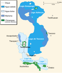
It has an average altitude of 2,240 m (7,349 ft) above sea level with most of the surface flat. The territory is mostly the bed of the former Lake Texcoco with soils of compressed clay over sand, with the exception of the Peñón de los Baños at 2,290 metres (7,513 feet) above sea level, made of basalt. Because it is mostly former lakebed, flooding (especially during the rainy season from June to October) and hailstorms in winter, are not uncommon. Flooding is often caused or exacerbated by the deteriorated drainage system. Aside from the one elevation, the far west of the borough corresponds to the far east of the former Tenochtitlan island. For this reason, about one quarter of the historic center of Mexico City belongs to the borough.
Neighborhoods
One of the notable neighborhoods of the borough is Magdalena Mixhuca. The community was a small island in Lake Texcoco in the pre Hispanic period and eventually became physically connected to the surrounding areas as the lake dried up. However, the area is still marked by the existence of small one-story houses with look very similar often painted some shade of orange, making it look like a small town. The kiosk in the community center is also painted the same color. Next to the plaza it is on is the church of Santa María Magdalena Mixhuca with an image of Mary Magdalene inside. The name Mixhuca comes from Nahuatl and means place of childbirth. The area is dedicated to Mary Magdalene because the first-born daughter of Moctezuma II requested such from Hernán Cortés .
Other notable neighborhoods include Colonia Balbuena, named after poet Bernardo de Balbuena, La Candelaria de los Patos, which gets its name from the large flocks of ducks that used to live here when the area was still lake, El Parque, Jamaica, Zaragoza, Romero Rubio and Gómez Fárias.
Landmarks
The borough is home to forty two traditional markets, with over 14,000 individual vendors. This includes three of Mexico City's large traditional markets, La Merced Market, Mercado de Sonora and Mercado Jamaica. La Merced is historically and culturally part of the historic center of Mexico City and is the largest retail food market in the city. The main building is 400 meters long with 3,205 stands mostly selling produce and groceries, meats and fish. There is a smaller section devoted to baskets, rope and handcrafts with another building selling leather, storage containers, ornamental plants and prepared food. This market is located in an area which has been a major market and receiving area since the colonial period. The entire neighborhood was filled in informal stands until the first building was constructed in 1860. Until the mid 20th century, La Merced was the main wholesale market, but this function was moved to the new Central de Abastos market in Iztapalapa. Mercado Jamaica is located in the neighborhood of the same name, next to the metro station named after it.
Reenactment of the Battle of Puebla
The Battle of Puebla has been reenacted each year at the Peñón de los Baños since 1930. Residents of this area dress as the Mexican forces, called Zacapoaxtlas and the French army and even includes the firing of cannons with blanks for effect. The reenactment is performed by hundreds of residents of three neighborhoods around Peñón de los Baños, with the event occurring in the neighborhood of that name. The divide to represent the French army and the band of peasants called Zacapoaxtlas along with Mexican soldiers which won the historical battle. The event begins early in the morning on May 5 with a salute to the Mexican flag and a parade to the Peñón de los Baños mountain. The first act occurs in Barrio del Carmen, then another act to commemorate the Treaty of Loreto and the Treaty of Guadalupe on Hidalgo and Chihualcan Streets. After this, there is a large shared banquet with food provided by area residents to the mock soldiers.
History
Pre Hispanic era
The emblem of the borough is the former Aztec glyph used to mark a village name Xochicán as it appears in the Mendocino Codex. The flower image means “place of fragrant flowers.”
Except for the far west which was part of the island of Tenochtitlan, the Peñón de los Baños and a couple of very small islands in-between, the territory of the borough was covered by Lake Texcoco from the pre Hispanic period into the colonial period. The oldest human settlements in the area were located in the Mixuhca and Peñón de los Baños, which were both originally islands in Lake Texcoco. The eastern end of Tenochtitlan was associated with docks and markets that handled the produce and other items that came over the Lake's waters into the city from other parts of the Valley of Mexico such as Texcoco, Chalco and Xochimilco. The lake in this area also contained part of the Nezahualcoyotl Dike, built to separate the shallow waters.
Colonial era
After the Spanish conquest of the Aztec Empire, the Spanish laid out their own capital over the ruins of Tenochtitlán.
Demographics
Since the 1990s, the borough has had a decrease in population, down from 462,806 from 2000. The borough's population accounted for 10.4% of the District's total in 1970. It accounted for 5.4% in 2000. One main reason for the decrease is the conversion of land from residential to commercial use.
The dominant religion is Roman Catholicism with over 90% of the population professing this faith. As of 2005, 4,489 people spoke an indigenous language, 1.1% of the total.
Education
There are 456 schools in the borough: 156 preschools, 200 primary schools, 73 secondary schools, 8 vocational high schools and 19 high schools. However, About eighty percent of the population has an education of less than high school level.
Public high schools of the Instituto de Educación Media Superior del Distrito Federal (IEMS) include:
Escuela Preparatoria Venustiano Carranza "José Revueltas Sánchez"
Socioeconomics
About 54% of the total population twelve or over is economically active. Most workers are between 35 and 39 years of age. As of 2000, over 98% of the working population was employed in either the formal or informal economies. Just under 80% are employed in commerce, 17.5% are employed in manufacturing and construction and .1% in agriculture.
The number of housing units in the borough has risen from 112200 units with an average occupancy of 3.3 in 1950 to 117800 units with 4.4 occupants in 1990. As of 1995, the average residential building was fifty years old. From 1990 to 2005, the numbers changed only slightly with 118400 units and 3.9 people per household. The improvement has much to with the decreasing population. Sewerage and electricity is available in over 97% of residential units but running water exists in just under 87%. Those without running water in the apartment have shared source of supply.
Transportation
TAPO
The Terminal de Autobuses de Pasajeros de Oriente, better known as TAPO is the main bus terminal for interstate travel to the east and southeast. It is located next to Metro San Lázaro and marked by its very large dome covering the structure. It was constructed by architect Juan José Díaz Infance and inaugurated in 1978. The outer rim of the circular interior contains ticket counters and boarding areas for bus lines such as Autobuses Unidos. The center contains a food court and other businesses.
Mexico City airport
Mexico City International Airport, known officially as Aeropuerto Internacional de Benito Juárez, is the main airport for Mexico City. It was formally named after the 19th century president Benito Juárez in 2006. The airport is owned by Grupo Aeroportuario de la Ciudad de México and operated by Aeropuertos y Servicios Auxiliares, the government-owned corporation, who also operates 21 others airports through Mexico. It is the country's busiest airport with 32 domestic and international airlines and offers direct flights to more than 100 destinations worldwide.
以上摘自英文维基百科「Venustiano Carranza, Mexico City」(有删节;去掉了表格、图片、参考文献和外部链接),按 CC BY-SA 4.0 使用。全文和最新版本请看原文。