舆图
伊斯塔卡尔科区 城镇
Iztacalco · 墨西哥城
- 国家 / 地区
- 墨西哥
- 一级行政区
- 墨西哥城
- 坐标
- 北纬 19.40°,西经 99.10°

示意图,边界据 Natural Earth,不作为划界依据。
更多资料
- 人口(Wikidata)
- 404,695(2020 年)
- 面积
- 23.2 平方千米
- 海拔(Wikidata)
- 2,236 米
- 所属行政区
- 墨西哥城
- 设立
- 1928 年
百科(英文)
这个词条没有中文维基百科条目,下面是英文维基百科的原文。
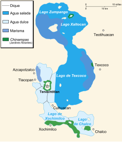
Iztacalco (Spanish: [istaˈkalko] ) is a borough (demarcación territorial) in Mexico City. It is located in the central-eastern area and it is the smallest of the city's boroughs. The area's history began in 1309 when the island of Iztacalco, in what was Lake Texcoco, was settled in 1309 by the Mexica who would later found Tenochtitlan, according to the Codex Xolotl. The island community would remain small and isolated through the colonial period, but drainage projects in the Valley of Mexico dried up the lake around it. The area was transformed into a maze of small communities, artificial islands called chinampas and solid farmland divided by canals up until the first half of the 20th century. Politically, the area has been reorganized several times, being first incorporated in 1862 and the modern borough coming into existence in 1929. Today, all of the canals and farmland are dried out and urbanized as the most densely populated borough and the second most industrialized.
The borough
The borough of Iztacalco is located in the east-center of Mexico City bordering Venustiano Carranza, Iztapalapa and Benito Juárez boroughs, as well as the Mexico State municipality of Nezahualcoyotl. It is the smallest of the city's boroughs. The territory is divided into thirty eight neighborhoods called "colonias" or "barrios" along with 220 major apartment complexes. The borough hall is located on Avenida Rio Churubusco in the Ramos Millán neighborhood.
Seventy-one percent of the borough is occupied by residences, commerce, and service establishments. Fifty-four percent of the territory is purely residential, down from 61% in 1980.%. There are 99,577 housing units, almost all of which are constructed of cinderblock and concrete. The average housing unit has 4.1 occupants. Many of these constructions are in some state of deterioration, which includes sixty percent of major housing complexes, as well as sixty percent of a type of housing situation, called a "vecindad." Mixed-use zones, with residences, offices, services, and certain industries, have increased from 8.6% to 17%. Eleven percent is dedicated to manufacturing. Ninety percent of the land is paved over with only about two percent considered to be green space.
Geography
The borough extends over 23.1 km2 (8.9 sq mi) or 2,317.4 hectares, all of which is urbanized. It accounts for 1.75% of the total territory of Mexico City, and it is the smallest of the 16 boroughs.
The land is flat and located on the lakebed of Lake Texcoco in the Valley of Mexico at an altitude of 2,235 meters above sea level. Today, however, the lake in this area has dried completely and the canals, wetlands and lake of the territory have completely disappeared. The climate is considered to be semi-arid and temperate, with only the area bordering Benito Juárez and Iztapalapa considered to be semi-moist with rains in the summer. Overall, the borough is the driest in Mexico City, with an annual rainfall of not over 600 to 700mm per year. With over 90% paved over, there are no wild habitats left in the borough. Of the 2.34% dedicated to green space, most of these are traffic islands on major thoroughfares.
There are only two parks in the borough. The Urbano-Ecológico School-Park is located on Calzada Ignacio Zaragoza in Colonia Agrícola Oriental, near the border of Iztapalapa. This park has less than one hectare. The other large green space is the parkland around the Magdalena Mixhuca Sports Center, which has been reforested with eucalyptus trees.
Demographics
Iztacalco is the most densely populated borough in Mexico City and the most dense subdivision in the country. As of 2020, the population was 404,695, with most being from the lower middle to lower classes. There are small communities of middle-class families in Reforma Iztaccihuatl, Militar Marte and Viaducto Piedad. Despite its density, the overall population of the borough has been dropping between one and two percent since 1990, but still about twenty percent of the current population moved into here from elsewhere in Mexico. The population is expected to continue decreasing.
About 5,400 people who speak an indigenous language, with thirty eight different indigenous ethnicities present. About 1,100 of these speak some form of Nahuatl, followed by Zapotec, Mixtec, Otomi, Mazateca, Mazahua and Totonaca. About 91% of the population is Catholic, with about seven percent belonging to Protestant or Evangelical churches.
History
While the most accepted interpretation of Iztacalco (from Nahuatl) is "house of salt," others have been proposed such as "place of white houses." Originally, the name was written "Ixtacalco" but its current spelling was adopted in the second half of the 20th century. The crest or seal of the borough is the Aztec glyph which has been used to designate the place since at least the time of the Mendocino Codex, which depicts the "house" and "salt" interpretations of the name. It contains a sun shining over a house. Inside the house, there is a grain of salt and two markings that represent raindrops' tracks.
Because it was originally an island well within Lake Texcoco, Iztacalco was settled by humans later than the rest of the Valley of Mexico. The history of Iztacalco begins in 1309. The Xolotl Codex states that Iztacalco was one of the people's last stops before they finally settled Tenochtitlan. The island was conquered and subject to the dominion of Texcoco as part of the territory of the Triple Alliance. From the beginning, inhabitants made a living by extracting salt from the brackish waters of the surrounding lake. This salt was consumed until the very early 20th century.
Economy
Iztacalco is ranked ninth in economic marginalization in Mexico City with over 32% considered to be living in poverty. Over 85% are considered to be at least moderately economically marginalized, the highest in the city. As of 2007, about 55% of the population over the age of twelve is employed either in the formal or informal economy, with most of these between the ages of 35 and 39. About 48% of those in the total workforce do not have work in the formal economy. Well over half the workforce is male but the percentage of women has been rising since 1990. 0.1% work in agriculture, 20.9% work in mining, construction, and manufacturing, and 75.7% work in commerce and services.
Eleven percent of the borough and 11.7% of establishments are dedicated to industry and manufacturing, the second highest percentage in the city. The Ciudad Deportiva de la Magdalena Mixihuca is the second largest industrial zone in Mexico City. Just under 50% of establishments are in commerce and just over 37% are in services, but there are no major office buildings. The borough has eleven hotels, one five-star, two four-star and four three-star.
Transportation
The borough has 53.8 km of primary roadway, 5.7% of Mexico City's total, with 6,082,261 m2 of paved surface. Major thoroughfares include the Viaducto Río de la Piedad which borders the borough on the north going east-west and connecting to the Mexico City-Puebla highway. It is bordered on the east by the Anillo Periférico, with the Circuito Interior passing through the center. Near the old village of Iztacalco is Eje 3 Oriente and Calzada de la Viga. Other important roads include Eje 2, Eje 6 Sur, Eje 1 Oriente and Eje 5 Oriente. Four lines of the Metro pass through the borough: Line 9, Line 1, Line 4 and Line 8. Three of these lines meet at Metro Pantitlán, a major hub of the transport system and a major connecting point for busses heading east into the State of Mexico. There are four lines of the trolleybus and Metrobús Line 2 passes through as well.
Metro stations
Education
There are twenty-three public daycare centers, run by various governmental agencies. There are 147 kindergartens, with 63 of these run by the delegation. There are 128 public primary schools. There are fifty-five public middle schools, thirty-five of which are general studies, and twenty are geared to vocational instruction. There are thirteen private middle schools. High schools include Plantel 2 de la Escuela Nacional Preparatoria (UNAM), la Preparatoria Iztacalco, dependiente del Instituto de Educación Media Superior del Distrito Federal (IEMS-DF) and Plantel 3 del Colegio de Bachilleres Metropolitano.
There are five centers dedicated to special education and nine centers that work with special needs children in the regular school system. There are fourteen vocational schools above the middle school level. It has eleven public libraries, mostly serving elementary school-aged children. It has ten casas de cultura which mostly serve only the neighborhoods in which they are found.
3.1% of the population is illiterate. To combat high dropout rates, the government of Mexico City offers stipends to families of school-aged children as long as the children remain enrolled in public schools.
以上摘自英文维基百科「Iztacalco」(有删节;去掉了表格、图片、参考文献和外部链接),按 CC BY-SA 4.0 使用。全文和最新版本请看原文。